
On the 8th Feb 1953, a B-29 took off from Hanscom Airforce base near Boston, Massachusetts to fly to Los Angeles, California, a journey of approximately 2600 miles or 4290 km and 12 hours in flight time.
But this would be no ordinary flight, this flight would be the first to use an internal navigation system to fly the plane along a preprogrammed route using no pilot, external signals or star guidance, just an internal reference frame using gyroscopes, accelerometers and gravity.
However, this was not an easy thing for some to accept, with some of the most influential scientists in the field saying that a black box solution that was completely independent of external information could never work.
And yet today, this is the basis of independent guidance for rockets, missiles, spacecraft, drones, UAVs, ships, and even submarines.
This is the flight that changed navigation forever and also kicked off miniaturisation of electronics that power the world today.
The idea of an autopilot to fly a plane independently of any human has been around for almost as long as the aircraft themselves with the first autopilot being developed by the Sperry corporation in 1912 and first demonstrated in 1914 by the founder’s son, Lawrence Sperry in Paris.
With aircraft at the time becoming more powerful and being able to cover longer distances, the flight times were now into the hours and becoming more fatiguing for the pilots.
The Sperry system was not the full autopilot that we think of today but more of an assistant to help keep the plane level and on the correct heading, greatly reducing the pilot’s workload.
It did this by connecting a gyroscopic heading and attitude indicator, via hydraulic controls to the elevators and rudder. This allowed Lawrence to fly with his hands away from the controls and visible to onlookers.
By 1930, Sperry had a system that could keep an aircraft on the straight and level for up to 3 hours. As time went by and adding extra instruments like radio navigation, planes could fly in the dark and in bad weather but this also meant they had to rely on an external source, and for military aircraft on combat missions deep into enemy territory where signals could be jammed, that was a problem.
This was a problem that Charles Stark “doc” Draper had been thinking about since the early 1930s and by 1945 he was the director of the MIT Instrumentation Laboratory.
He had been working on the A-1 gyroscopically stabilized radar gun with Colonel Lee Davis when the news of Japan’s surrender and the end of WW2 came through.
This meant that many military projects for weapons that were no longer needed were cancelled and Draper saw this as an opportunity to work on the self-contained inertial navigation system he had been thinking of for years and based on his extensive experience of gyroscopes and stabilized platforms.
Draper discussed it with Davis and realized that even though the war was over, based on the experience of bomber crews, new bombers and missiles would need navigation systems that would be impervious to external jamming for long flights over enemy territory. However, a totally independent guidance system was seen many by top scientists as an impossible goal.
As the war in Europe had ended already, the U.S. had gathered Germany’s top rocket engineers led by Werner Von Bruan in operation “Paper Clip”. This brought them to the U.S to work on the next general of missiles and eventually the Apollo moon program for America.
A key part of the rocket work was the guidance system that had been developed for the V2 rocket but the top brass of the U.S military was weary of having so many German scientists working on key technologies like the guidance systems which were to be used in many other applications.
So while Draper may well have had what was seen by some as a far-fetched proposition, he and his team were seen as an essential alternative to the German teams and contracts were given to Draper to prove he could make such a system.
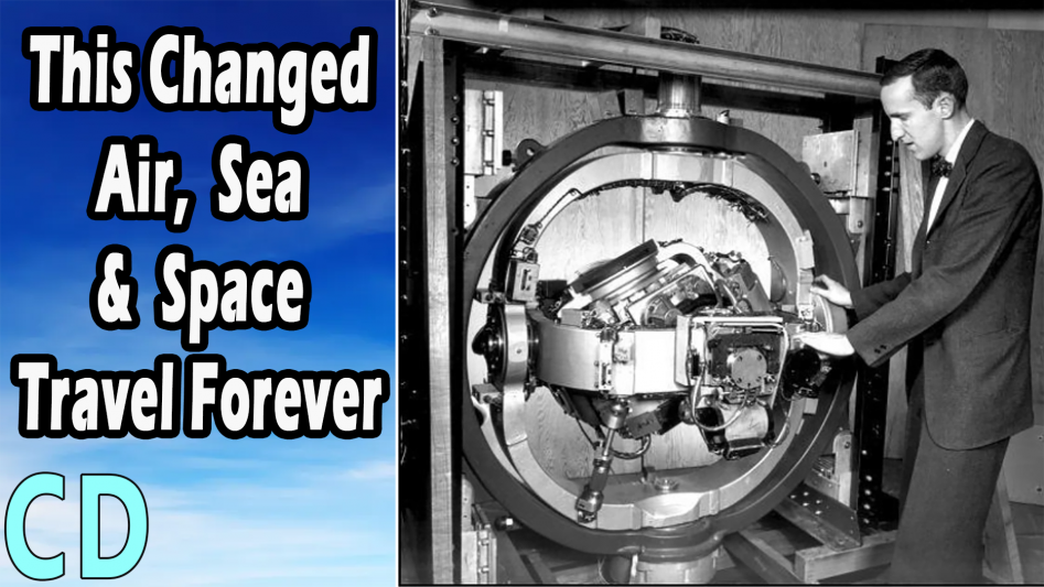
By 1949 Draper and his MIT team had created the 1800kg FEBE Inertial navigation system, however, due to the quality of the gyroscopes available at the time, gyro drift was a major issue and inaccuracies started to built up which could affect the course of the aircraft. So a solution was to use a celestial star tracker that would lock on to a celestial body or the sun once the aircraft was at cruising altitude.
This extra data would then allow for the inaccuracies to be corrected in flight, but Draper thought this was a temporary and not very elegant solution and it could still be affected by weather, aurora, meteor showers, and enemy countermeasures.
Even without the star tracker the accuracy of the gyro system was still good over moderate distances and this was encouraging enough that the Air Force issued a follow on project to Drapers team at MIT to build and test a completely self-contained navigation and guidance system using just inertial and gravitational inputs. This project was named Space Inertial Reference Equipment (SPIRE).
One of the biggest issues that had to be overcome was the direction of the vertical or where the centre of the earth was in comparison to the moving guidance system and this is crucial to any Inertial guidance unit.
You see, in a gyro system, once the gyros are spinning in their gimbals and the exterior of the system is moved in any direction, the gyros will try to stay in the same orientation as when it started. This what the “inertial” in inertial guidance means, and is what makes gyros so very useful.
Once the inertial guidance system is in an aircraft for example and it is initialized on the ground at the start of a flight, when the aircraft is moving in flight, be that pitching up and down, rolling about the longitudinal axis, or yawing, the stabilized platform always remains in the same relative position to the ground where it was initialized, and there in lays the problem.
The earth contrary to what flat earthers believe, is not flat and as the plane moves along it is going around a giant sphere and therefore it is no longer perpendicular to the ground where it started, the further it goes the more the inertial guidance system will become tilted out of alignment compared to its starting point.
This is where to many in the scientific community, this seemed an impossible task because, based on Einstein’s general theory that an observer inside a closed box could not distinguish between the effects of linear acceleration from the effects of a gravity field itself.
Here the guidance system is the observer in a closed box and it can’t tell the difference between the plane accelerating in a climb or dive from the normal gravity in a flat-level cruise. Just like instances of pilots at night who have flown into the ground because their instruments had failed and they couldn’t tell if they flying straight and level or actually diving towards the ground.
But Draper’s team had already figured out that if they used a dampened pendulum that would always point towards the centre of the earth and linked it to a servo mechanism, the whole assembly could be kept perpendicular to the ground wherever they were.
Although this system could tell when it was in a moving vehicle it couldn’t tell how far it had travelled. To do that Draper added highly accurate accelerometers in the same three axes of the gyroscopes and a clock. Now movement could be calculated over time and this could be used to tell how far the system had travelled and in which direction.
All these electrical signals were fed in an analogue computer along with a programmable flight route which would tell the system where it should go. The output of the computer was interfaced to the flight controls of an aircraft and in theory it should be able to fly it from one place to another without and external input or signals.
By 1953 the system had been tested several times and Draper was so convinced that it would work he arranged to fly from Massachusetts to California the day before a top-secret government-sponsored conference on inertial navigation that was scheduled to begin in Los Angles, California, on Monday, 9th February 1953.
The SPIRE system was loading in a B-29 on loan from the U.S Airforce and after a few test flights they took off for California, it should be noted that this first version didn’t do automatic take-off and landing so they waited till it was at 10,000ft before the switch over.
Everything went well until they got to the Rocky Mountains when they ran into dense cloud cover. The plane then hit turbulence and turned to the right at about 10-12 degrees which panicked the pilot who was watching the wheel.
Draper knew that something was happening because they could see the gimbals moving a lot with respect to the aircraft but Draper told the pilot to let it carry on and see what it did, SPIRE eventually levelled out the aircraft and they carried on to California.
What they didn’t know until after the flight was that they had hit a weather front over the Rockies and were being blown off course. SPIRE detected that and made a course correction to bring it back on track and when the cloud cover broke, they could see that they were exactly on course once more.
After they had landed and the actual accuracy could be worked out from the data they recorded for a 12-hour flight over 2600 miles or 4190km.
Bearing in mind that this was the first full-scale test for a prototype system and relying on nothing more than mechanical gyroscopes, accelerometers and an analogue computer, it was within 9 nautical miles or a 16.6km. This proved beyond any doubt that initial guidance could be used for long-distance navigation.
By 1962, it had been developed and was the inertial navigation system for the Polaris submarine-launched ballistic missile. By then it had gone from 1200kg and the size of a large refrigerator to 63kg and the size of a large basketball. Over the 2500-mile or 4000km range of the Polaris, the accuracy was within 900m but that would steadily get better over the coming years.
On 9th Aug 1961, the instrumentation laboratory was awarded the very first Apollo contract to design and build a fully integrated, deep-space capable Guidance Navigation and Control system for the manned moon missions with the capability to go Mars and beyond.
Key workers from the Polaris development team contributed to the Apollo guidance system and their choice to use the newly developed integrated Circuit or IC technology over individual transistor components for the guidance computer to keep the weight, size and power requirements to a minimum, kick-started the miniaturisation of electronics that we take for granted today.
Since then, mechanical gyroscopes have been replaced by a host of new and highly accurate technologies the likes of MEMS or Micro-Electro-Mechanical Systems directly embedded into silicon which allow complete systems to be built onto a chip.
To give an example of how things have progressed The VN-200 from Vectornav is a miniature, high performance GPS-Aided Inertial Navigation System that combines 3-axis gyros, accelerometers and magnetometers, a high-sensitivity GPS receiver and the computing power to provide optimal estimates of position, velocity, and attitude and all in a package size of 24 x 22 x 3mm and requiring just 440mw of power and weighing in at 4g.
Doc Draper started an entire industry and rightly became known as the father of inertial navigation which made both MIT and the instrumentation laboratory which was spun off in to an independent entity years later, in to world leaders and the spinoffs from it have found their way in many of the things we use in everyday life from smartphones to cars, drones, planes, ships and spacecraft to name but a few.
So I hope you enjoyed the video and if you did then please thumbs up share and subscribe and I’ll se you in the next video.